Chapai Nawabganj (in Bengali: চাপাই নবাবগঞ্জ) is located on the north-western part of Bangladesh. It is a part of the Rajshahi Division. Originally, it was a sub-division of Malda district. In 1947, it was severed from Malda and was given to East Pakistan as a sub-division of Rajshahi district. It became a separate district of Bangladesh in 1984. The north and west part of Chapai Nawabganj is bounded by Malda and Nadia districts of India, east is by Naogaon District and south-east is by Rajshahi District.
Area Total 1702.56 Km (657.36 Square Mile)
Population (2011)
Total :1647521 Person
Density :970/Km (2500/ Square Mile)
Upazila Road :343.00 Km
Union Road :477.00 Km
Village Road-A :1032.00 Km
Village Road-B :1506.00 Km
Upazila :5 Nos
Union :45 Nos
Pourashava :4 Nos
Percentage of Literacy
Total ??%
Etymology
The name 'Chapai Nawabganj' is not very old. Before 2001, it was known as only Nawabganj or Nobabganj. In the pre-British or British-raj era, this place was a vacation spot for the nawabs of Murshidabad and Daudpur Mouja was the particular place of their vacation. The nawabs used to come here for hunting. That's why this place was known as 'Nobabganj' as Ganj means place. It is believed that the Nawab of Bengal (Bangla-Bihar and Odisha) Sarfaraz Khan (1739-1740 AD) once came here for hunting and built a tent at this place. From then, this place is known as Nobabganj. But most researchers believe that during the reign of Alivardi Khan (1740-56 AD), this place was given the name Nobabganj.
At the start and middle of the 18th century, people afraid of British rule migrated from Kolkata to here to a great extent and made this a very busy populated place. There was a post office at that time which was located in the village named 'Chapai'. This migration led to the enlargement of the village 'Chapai'. The place was known widely as Chapai Nawabganj.
There is no strong historical proof about the name of this place, but people usually believe in two different sources:
1. There is a village about 5/6 miles away from the current town Nawabganj named Maheshpur. During the Nawab era, a dancer named 'Champa Bati' or 'Champa Rani' or 'Champa Bai' lived there who was very famous to the Nawabs, and they usually visited this place to watch her perform. Based on her name, this place is called Chapai Nawabganj.
2. Another popular belief is that the king Lakhindar lived here and his capital's name was 'Champok'. Dr. Muhammad Shahidullah (1885-1969 AD) cited in his book 'Bangla Sahitter Kotha' that the enemy of Laoson entered into Gaur through 'Jamutinagar'. 'Jamuti Nagar' still exists in this area. Based on these beliefs, researchers believe that the home of Behula's father-in-law was in 'Champok Nagar' and Chapai Nawabganj came from this 'Champok Nagar'.
History
Chapai Nawabganj was one of the sub-divisions of the former Rajshahi zilla. Chapai Nawabganj was part of ancient gaur capital. It is said that this area had strategic and commercial importance due to its location at the junction of the rivers Mahananda and the Ganges. Because of its importance, Alivardi Khan founded Nowabganj town which in course of time known as Nawabganj. Until 1947, Nawabganj was a thana under Malda district, India.
The gateway of North Bengal, Malda was once the capital of Gour-Banga, with 3456 sq. km of land classified as Tal, Diara, and Barind. Malda awaits the advent of tourists and people of archaeological interest with its wealth to be enjoyed and its huge potential to be explored.
This portion of the earth is washed by the waves of the rivers Ganges, Mahananda, Fulahar, and Kalindri. It has witnessed different empires which were raised, flourished, and then cast down near oblivion by a successor kingdom built up on the relics of its predecessor. Panini mentioned a city named Gourpura, which by strong reason may be identified as the city of Gouda, ruins of which are situated in this district. Examples are legion of the relic of a predecessor kingdom being used in the monuments of the successor kingdoms. It had been within the limits of ancient 'Gaur' and 'Pandua' (Pundrabardhana).
This district, Malda, formed in 1813 out of the outlying areas of Purnia, Dinajpur, and Rajshahi districts. At the time of Dr. B. Hamilton (1808-09), the present thanas of Gazole, Malda, Bamongola, and part of Habibpur were included in the district of Dinajpur and the thanas of Harischandrapur, Kharba, Ratua, Manikchak, and Kaliachak were included in the district of Purnia. In 1813, in consequence of the prevalence of serious crimes in the Kaliachak and Sahebganj thanas and also on the rivers, a joint magistrate and deputy collector were appointed at English Bazar with jurisdiction over a number of police stations centred around that place and taken from the two districts. Thus the district of Malda was born.
The year 1832 saw the establishment of a separate treasury, and in 1859 a full-fledged magistrate and collector was posted. Up to 1876 this district formed part of Rajshahi Division, and from 1876 to 1905 it formed part of Bhagalpur Division. In 1905, it was again transferred to Rajshahi Division, and until 1947 Malda remained in this division. In August 1947 this district was affected by the Partition of India. Between 12 and 15 August 1947 whether the district would become part of India or Pakistan was unknown, as the announcement of the Radcliffe Line did not make this point clear. During these few days the district was under a magistrate of East Pakistan until the details of the Radcliffe award were published and the district became part of West Bengal on 17 August 1947. Five thanas were given to Pakistan under the district of Rajshahi which later formed as Chapai Nawabganj.
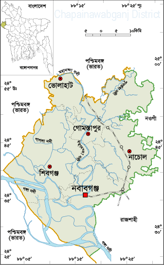
Geography
Geographical Location
Chapai Nawabganj is the most western district of Bangladesh. Rajshahi and Naogaon are on the east, and Malda of West Bengal, India is on the north. The western side is surrounded by the river Padma and Malda district, and Murshidabad of West Bengal, India is on the southern side. Chapai Nawabganj is situated between the latitude 24°22' to 24°57' N and longitude 87°23' to 88°23' E.
Topography
Chapai Nawabganj District (Rajshahi division) has an area of 1702.55 sq. km. Many rivers flow over this area. The main rivers are the Ganges and Mahananda.
Google Earth view
Most of the land in this area is plain land with many small ponds and water reservoirs. However, recently, the geography has changed due to erosion by the river Padma (Ganges). Overload of river sediment caused by the Farakka Barrage eroded the river banks and created a large area of land full of sand, which almost looks like a small desert. Four to five small union parishads like Narayonpur, Johurpur, Sundorpur, and Baghdanga have shifted to the other side of the river Padma.
Economy
This district is mainly plain land with rivers. The whole district is full of fertile land with proper irrigation facilities. That is why the economy is totally dependent on agriculture. Chapai Nawabganj is called the capital of mangoes in Bangladesh because this summer fruit is the main product that sustains the economy. As there are a number of rivers, many people also depend on fishing. The main parts of mango production are Shibganj, Bholahat, and Gomastapur upazilas.
Culture
Gombhira Gaan
Gombhira Gaan is a kind of folk song popular in this district. Nowadays, Gambhira reflects contemporary social problems through witty dialogue, songs, dances, and jokes. This is a central part of any cultural celebration in this district, providing entertainment and social commentary.
Local Language
The people of Chapai Nawabganj use the Bengali language but have their own dialect, which has many words different from standard Bengali.
Places of Interest
Choto Sona Mosque
One of the most graceful monuments of the Sultanate period is the Chhota Sona Masjid at Gaur in Chapainawabganj. Built by Wali Muhammad during the reign of Sultan Alauddin Husain Shah (1493-1519), it was originally roofed with 15 gold-gilded domes, from which it derives its name. Beside this mosque, the great martyr Birshreshtha Captain Mohiuddin Jahangir lies in peace.